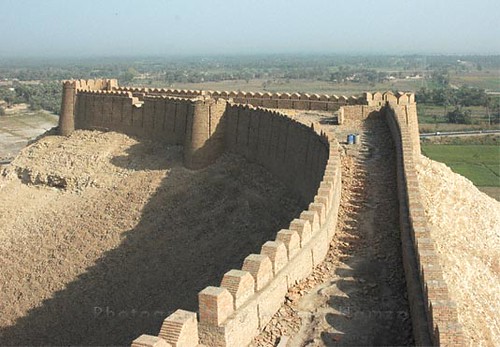
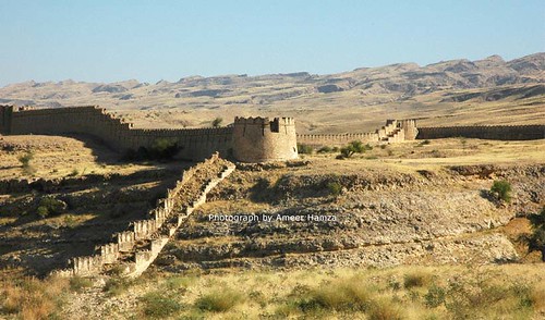
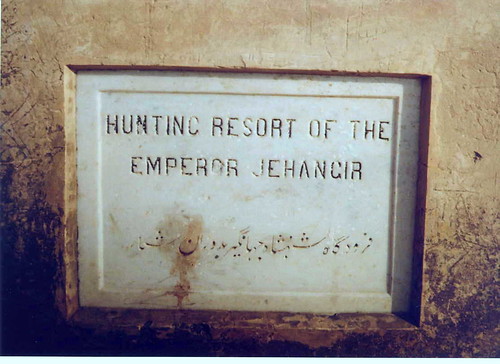
 Ranikot Fort is the world's largest fort with a circumference of about 29 km or 18 miles. Who constructed it first and why? Is an enigma yet to be resolved by researchers. Some archaeologists attribute it to Arabs, possibly built by a Persian noble under the Abbasids by Imran Bin Musa Barmaki who was the Governor of Sindh in 836 CE. Others have suggested a much earlier period of construction attributing to at times the Sassanians, Persians, and at times to the Greeks. Despite the fact that a prehistoric site of Amri is nearby, there is no trace of any old city inside the fort and the present structure has little evidence of prehistoric origins.
Archaeologists point to 17th century CE as its time of first construction but now Sindh archaeologists agree that some of the present structure was reconstructed by Mir Karam Ali Khan Talpur and his brother Mir Murad Ali in 1812 CE at a cost of 1.2 million rupees.
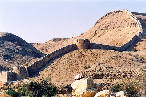
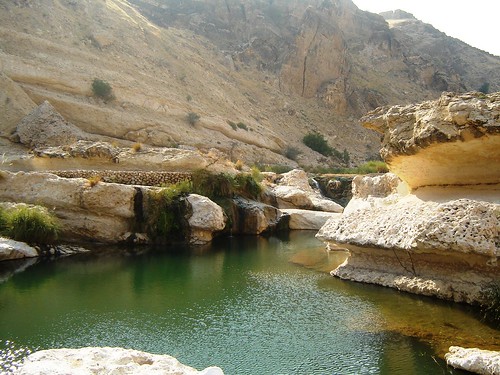
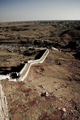
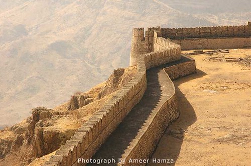
Fort Ranikot is located in Lakki Mountains of the Kirthar range on the right side of the mighty Indus River at a distance of about 30 kilometers from the present day town of Sann. A mountainous ridge, Karo Takkar(Black Hill), running north to south, forms its western boundary and the 'Lundi Hills' forms its eastern boundary. Mohan Nai, a rain-stream enters the fort from its rarely used western 'Mohan Gate', where it is guarded by a small fortification, changes its name to 'Reni' or 'Rani Nai' or rain-stream and gives the fort its name. Ranikot is thus the 'fort of a rain stream' - Rani. It runs through it, tumbles in a series of turquoise pools to irrigate fields and leaves the fort from its most used 'Sann Gate' on the eastern side. It then travels about 33 kilometers more to enter the Lion River - Indus.
Most of the twenty kilometers long wall is made of natural cliffs and barricades of mountainous rocks which at places rise as high as two thousand feet above sea level! Only about 8.25 km portions of its wall are man-made, built with yellow sandstone. This was first measured on foot by Badar Jamal Abro along with local guide Sadiq Gabol . As one enters the fort, one can find hills, valleys, streams, ditches, ponds, pools, fossils, building structure, bastions, watchtowers, ammunition depots, fortresses - all inside Ranikot, adding more to its beauty and mystery. A spring emerging from an underground water source near the Mohan Gate is named as 'Parryen jo Tarr' (the spring of fairies). According to a tale told by the local inhabitants, fairies come from far and wide on the Ponam Nights (full moon) to take bath at this spring near 'Karo Jabal'! Splashing sounds of water falling on the rocks can be heard at another spring, Waggun jo Tarr or "the Crocodile Spring", named so as crocodiles once lived there.
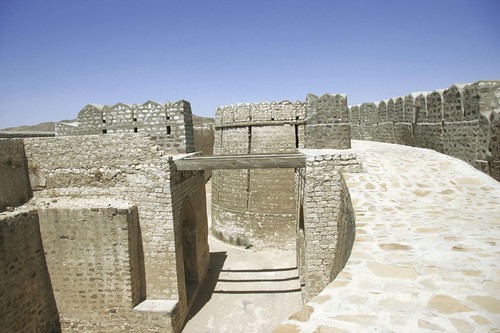
Within Ranikot, there are two more fortresses - Meeri and Shergarh, both have 5 bastions each. Meerikot takes its name from the word 'Mir' meaning top (for instance the top of a hill, chief of any baloch tribe, etc.). Both the main Ranikot and the inner Meerikot have similar entrances - curved, angulated with a safe tortuous path. "The bridge in front of Ranikot resembles to a smaller bridge in front of a fortress in Verona, Italy" writes Ishtiaq Ansari, the writer of 'Sindh ja koat aaein qillaa' (Forts and Fortresses of Sindh) and a member of Sindh Exploration and Adventure Society. From the military point of view, Meerikot is located at a very safe and central place in the very heart of the Ranikot with residential arrangements including a water-well. Talpur Mirs used Meerikot as their fortified residence. One can explore ruins of the court, harem, guest rooms, and soldiers quarters inside it. Its 1435 feet long wall has five bastions. Every structure in the Ranikot has its own uniqueness and beauty. Looking up from Meerikot one can find another fortified citadel - Shergarh (Abode of Lions) built with whitish stone, it too has five bastions. Though its location at 1480 feet above the sea level makes this fortress a unique structure, it also makes it equally difficult for supply of water, which can only be had from the brooks and rain streams, hundreds of feet below.The steep climb up to Shergarh gives a commanding view down over the whole fort and its entrance and exit points. On a clear day one can even see Indus, 37 kilometers away to the east.
Beside the Mohan Gate and the Sann Gate, there are two more gates, rather pseudo gates. One is towards the side of ancient town of Amri. This 'gate' is called the 'Amri Gate'. Certainly it takes its name from the prehistoric ruins of Amri, but it must have taken this name much later than the times of Amri as the fort itself doesn't appears to be as old as the Amri itself. In fact there is a bridge over rain stream 'Toming Dhoro' exiting from the fort called 'Budhi Mori'. The breach in fort wall due to the river stream has been referred as a gate. Similarly, the Shahpir Gate to the south also appears to be a pseudo gate taking its name from a limestone rock with a rough shape of foot imprinted on it. The sacred footprint supposedly belongs to Hazrat Ali or some other religious personality and is venerated by locals. It seems to be a later breach in the fort wall instead of a formal gate because one can't find any bastion or watchtower or their remains at the site, needed to guard any formal entrance or exit points.
A mosque found in the fort appears to be a later modification of a watchtower or a later construction. Scattered animal skeletons and prehistoric fossils can be found on the top of Lundi Hills. One of the three graveyards has about four hundred graves made of Chowkundi like sandstone with engraved motifs of sunflowers and peacocks. Whether we can call them as theriomorphic and phytomorphic motifs is an open question. Another one appears to be a graveyard of Arabs. The third one, about a mile away from the Sann Gate, had sixteen or seventeen graves earlier but now there are only four graves. The local inhabitants call it the Roman's graveyard.
More Pics: [CLICK 2 ENLARGE]


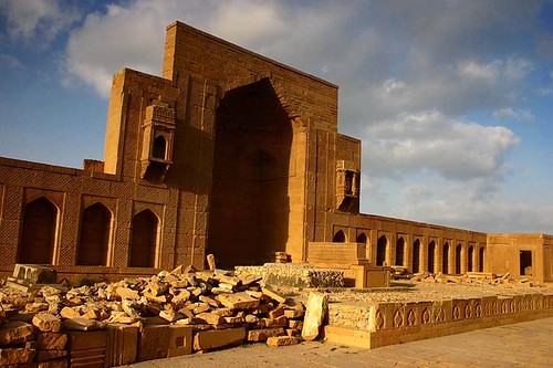
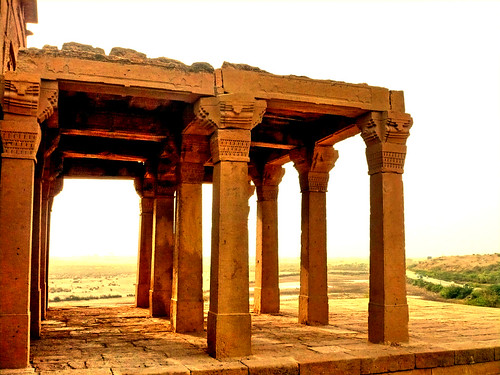
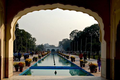
 One of the largest necropolises in the world, with a diameter of approximately 8 kilometers, Makli Hill is believed to be the burial place of some 125,000 Sufi saints. It is located on the outskirts of Thatta, the capital of lower Sindh until the seventeenth century, in what is the southeastern province of present-day Pakistan. Legends abound about its inception, but it is generally believed that the cemetery grew around the shrine of the fourteenth-century Sufi, Hamad Jamali. The tombs and gravestones spread over the cemetery are material documents marking the social and political history of Sindh.